
Weather Alert
Thursday, October 28, into Friday, October 29!
It appears that significant portions of North Texas will be impacted by frost tonight. In checking www.weather.com for expected low temperatures tonight, it appears that some of the coldest weather will be in North Central Texas.
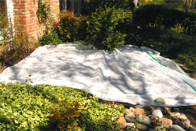
Plants that are most sensitive to frost include tomatoes, peppers, coleus, basil, bougainvillea, aglaonemas, tropical hibiscus and dieffenbachias, among other tropicals. They will benefit from a covering of lightweight frost cloth or an old sheet. Plastic films can actually do more harm than good and are not recommended.
There is good likelihood that tonight’s cold spell will be followed by several weeks of good growing weather, so if you can protect your plants this one time, you can probably coax a good bit more out of your autumn garden.
That said, this validates why we don’t plant new sod after mid-September, and why we don’t recommend feeding after the first weekend of October. These early cold spells aren’t all that uncommon.
When I think of weather, I think of Brad Barton. He and I worked at the former station for more than 30 years together, and we both joined WBAP within the past year. He serves as their Chief Meteorologist. Here is what Brad prepared for you:
The National Weather Service is issuing a Frost Advisory for Bosque, Collin, Comanche, Cooke, Delta, Denton, Eastland, Erath, Fannin, Grayson, Hamilton, Hood, Hopkins, Hunt, Jack, Lamar, Lampasas, Mills, Montague, Palo Pinto, Parker, Somervell, Stephens, Wise and Young counties from 3-9AM Friday. Dallas and Tarrant counties are NOT INCLUDED as the ‘urban heat island’ effect of heat-retaining concrete and glass usually adds a couple degrees to the air temperature inside the metro loops of 820 and 635.
Synopsis: The massive storm system now in Southeastern Canada is drawing a dry, continental-Pacific air mass down through the partially snow-covered Rockies, lowering its temperature and raising its pressure as it surges toward Texas tonight. If winds can go virtually calm region-wide after midnight, the combination of clear skies, radiational cooling, marginal humidity and high pressure will squeeze water vapor directly into ice-crystals, bypassing the condensation process. Frost formation can take place at up to 38F but such situations are somewhat rare. Any deviation involving dew, patchy clouds or light winds will prevent formation of frost as this is such a marginal event. Actual air temperatures are expected to range between 35 and 41 degrees.
So far anyway, we’re enjoying a very gentle descent toward winter temperatures.
Brad Barton, Chief Meteorologist WBAP 820 AM/96.7 FM
http://www.bradsweather.com
One Additional Note:
Because of this weather alert, we are sending e-gardens out a few hours early today. Any further updates will be addressed on my Facebook page. Here is a quick-link to it.